Waves crash along North Carolina’s Outer Banks as Hurricane Erin drives dangerous surf and flooding toward the East Coast. Image: The Indian Express
(The Post News)– Hurricane Erin, now a Category 3 storm, is stirring life-threatening conditions along the U.S. East Coast. Forecasters warn of flooding, high surf, and dangerous rip currents as the storm grows stronger in the Atlantic.
Erin will not make landfall but is expected to push large waves toward the Bahamas, Bermuda, Canada’s Atlantic coast, and the eastern United States. Meteorologists say the system is unusually large and still expanding.
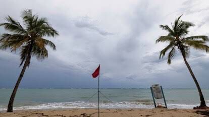
Tropical storm warnings cover the Turks and Caicos Islands and the southeast Bahamas. In North Carolina’s Outer Banks, officials declared a storm surge watch. Rising water threatened to block the main highway, promting evacuation orders in Hattera and Ocracoke islands.
Authorities urged swimmers and surfers to stay out of the water. On Monday, lifeguards pulled dozens from rip currents at Wrightsville Beach, North Carolina.
As of early Tuesday, Erin carried sustained winds of 115 mph (185 km/h). “Even without a direct hit, this storm will bring flash flooding, coastal surge, wind damage, and dangerous currents,” said BBC Weather’s Helen Willetts.
Erin is the first hurricane of the 2025 Atlantic season. Over the weekend, it briefly strengthened to Category 5 before weakening again. In Puerto Rico, fierce winds knocked out power for 150,000 people. By Sunday night, emergency crews restored service to most homes.