Storm of the Season: Hurricane Helene Intensifies, Putting Millions of Floridians on High Alert.
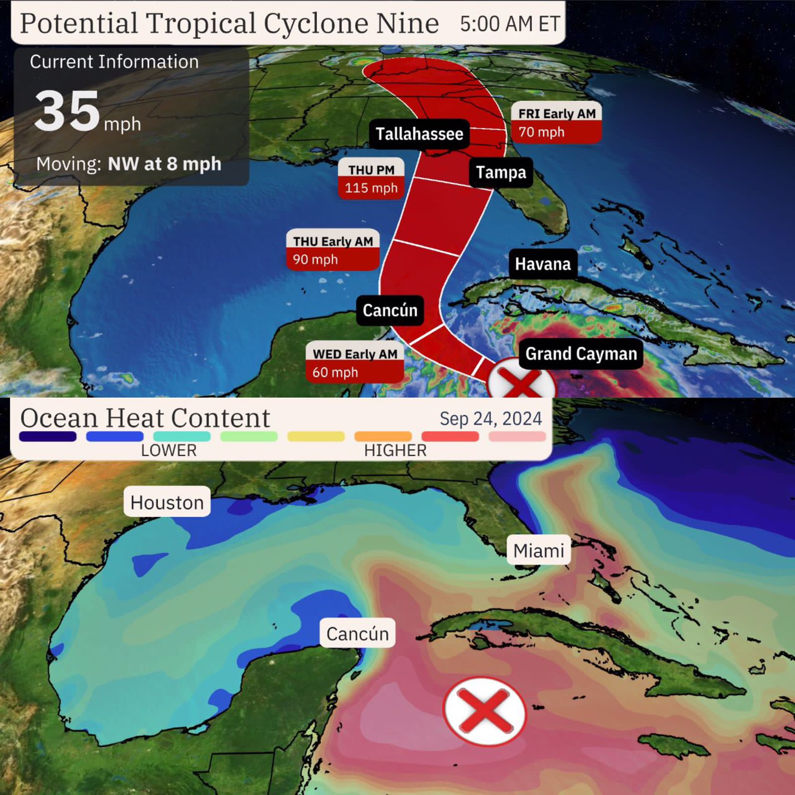
A powerful storm system brewing in the Caribbean Sea is forecasted to intensify into Hurricane Helene, potentially bringing life-threatening storm surge and hurricane-force winds to Florida and the Southeast. According to the National Hurricane Center, Helene is expected to reach Category 3 strength by Thursday, fueled by the Gulf of Mexico’s record-high heat content.
The system’s rapid intensification is anticipated to continue, with hurricane and tropical storm watches issued for parts of Florida. Florida Governor Ron DeSantis has declared a state of emergency for 41 counties, enabling expedited preparations and coordination. Tampa General Hospital has erected a 10-foot-high flood barrier around its facility due to potential storm surge and track shifts.
As Helene approaches, residents from Florida’s Gulf Coast to eastern Louisiana are advised to remain vigilant. The National Hurricane Center warns of far-reaching storm surge, wind, and rainfall impacts, particularly to the east of the system. Heavy rainfall is expected across the Southeast, with a level 2 of 4 risk of flooding rain in place for much of Florida, Georgia, Alabama, and parts of the Carolinas.
Helene’s projected landfall in Florida’s Big Bend region could bring strong winds and torrential rainfall to Georgia and the Carolinas by Friday, leading to dangerous flooding and significant power outages. This would be the fourth hurricane to make landfall in the US this year and the fifth to hit Florida since 2022, exacerbating the state’s insurance market crisis.
Tropical alerts are in effect for portions of the Yucatan Peninsula, the Greater Antilles, and Florida, indicating tropical storm conditions are expected and hurricane conditions are possible within the next 36-48 hours. The storm is currently located 120 miles west of Grand Cayman, with winds of 35 mph.
The National Hurricane Center predicts Helene will near Cancún, Cozumel, and western Cuba by Tuesday, enter the southern Gulf of Mexico as a hurricane by Wednesday, and make landfall as a major hurricane on Thursday. On Friday, the system is expected to push inland quickly with lingering strong wind gusts and locally flooding rain.
Residents are advised to stay informed and follow evacuation orders to ensure safety. With Helene’s impacts potentially extending well beyond its center, it is crucial to remain vigilant and prepared for the storm’s arrival.